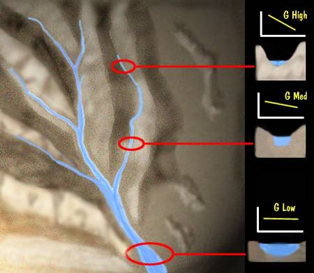
As you move downstream several natural changes are apparent.
1.) Discharge increases
2.) stream cross section increases
3.) velocity increases slightly
4.) gradient decreases
The one contradictory point might be the velocity. It would seem that water at a higher gradient would be faster than water further down. Part of the reason for this is that a shallow stream bed has more resistance to movement than a deep channel.
There is an equivalent force of gravity acting in the downward direction at both the beginning and ending of a stream, but as the steam continues down, there is more pressure of water behind it.
There is usually an increase in volume as tributary streams join the main stream. These secondary streams add volume to the main stream and velocity.
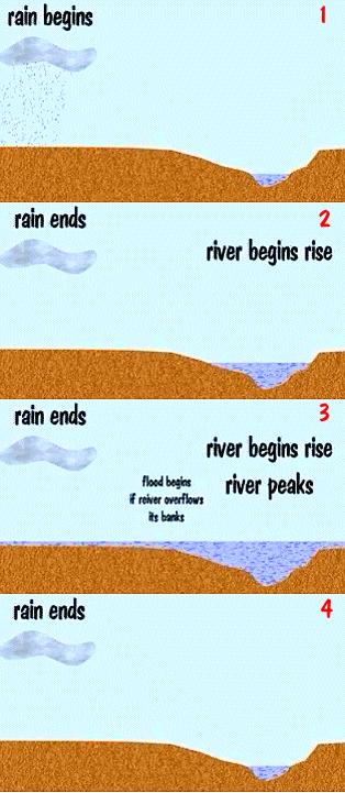
A flood is when a stream rises over its natural bank and spreads away from the channel. Flooding is caused by excess water interring the channel. More water enters than can be removed by the channel.
The water may come from several sources, rain, snow melt, or glacier melt.
When rainfall is the cause there is a delay between the time of maximum rain flow and the peak of the flood flow. It takes time for the ground to become saturated, and then for the rain to join into small rivulets and reach the stream channel.
Once the peak flow of the flood has arrived, it tend to fall back to a non-flood profile more slowly.
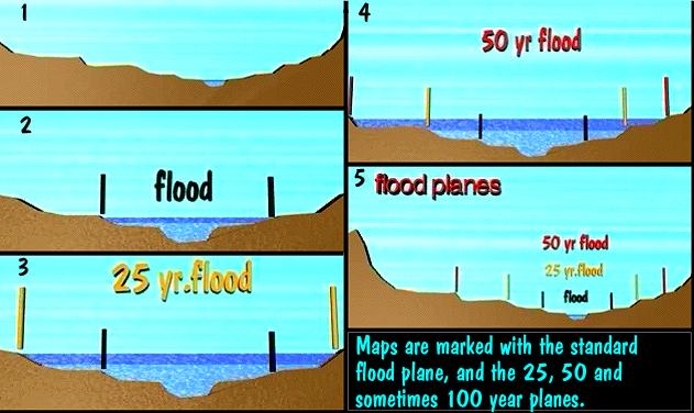
Historically we can plot on a map the width of various floods and then begin to analyze the time between them. Once plotted the map will show the various flood planes, "a normal" flood, a 25 year flood, a 50 year flood and sometimes even a 100 year flood.
With the map you are armed to decide if you wish to build within any particular flood basin, The maps are also used by insurance companies to set flood insurance rates. (Or to deny them.)
Base level is the elevation which determines the deepest channel a stream can cut. If the stream reaches the ocean, then ocean level is the base level of the stream.
A lake acts as the local "base level" for streams entering it. The lower end of a lake can be further eroded and thus pass more water out until it reaches another lake or the ocean.
If a stream empties into a closed basin (like a closed valley), then the valley floor becomes the base level for the stream.
| NEXT | TOC | PREV |