In the 19th century it was decided that the earth was cooling and shrinking and that is why mountains were rising. The crust was compressing which explained the folded strata. Seismic areas were areas where contraction was happening "right now". Problem: it could not explain why there were continents, nor their distribution, nor why there were growing valleys.
Beginning of the 20th century, it was decided that the earth was expanding and not shrinking after all. It was actually heating and expanding due to the newly discovered "radiation". Since the earth was expanding the crust would crack into fragments creating the various continents. It was, unfortunately a little harder to explain why some places, like mountains where expanding so much faster. Also after a long enough time the folds should begin to straighten out. (Another inconvenience to the theory.)
Later in the 20th century came the idea of continental drift and plate tectonics. The first theory that could actually explain everything that we observe.
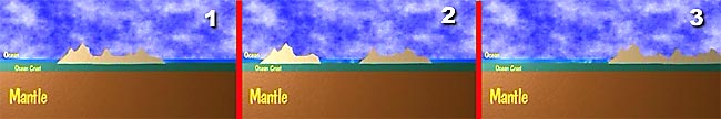
Alfred Wagner was the first to propose the idea that the continents were moving across the surface of he earth and they broke up from time to time and may have recombined from time to time. (Digram below: 1-2-3)
It helped to explain the really good match of the shorelines on both sides of the Atlantic. He claimed that the all the continents had once been part of a "super continent" called Pangaea (meaning "all lands").
The top of it was comprised of "Laurasia", and bottom was "Gondwanaland". Gondwanaland got its name based on some rock formations in India, which also happened to be found in Africa and South America. An interesting coincidence unless they once connected.
The theory languished for some time as no one was able to explain how the continents could overcome the friction and move over the ocean floors.
One important development was the discovery that the magnetic poles were not fixed in time and space. Some igneous and sedimentary rocks were able to become magnetized in the direction of the poles as they were formed. More importantly they indicated that the poles actually reversed their polarity from time to time, with magnetic north being replaced by magnetic south.
Not only do the poles reverse, but rocks found at different latitudes would, by necessity point in slightly different directions. The problem was that many older rocks in Europe indicted one direction while those in North America indicated a different direction. Although the poles do seem to reverse there is no evidence that they wander around the earth. They seem to fit closely with the rotational access although not exactly.
The only explanation for the different data was that the continents must move about if their magnetic movements were believed to be true. If the magnetic poles were not wandering around the earths surface then the land masses must be.
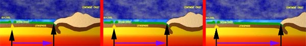
Up steps Harry Hess of Princeton university in 1962 and he proposed that the sea floor must be spreading from the mid-Atlantic ridge. "Sea floor Spreading" was proved by paleomagnetism. Three other people proposed the test of using the magnetism as a pointer. If the sea floor were spreading then it should act like "a chart recorder" from the middle - out. It should have recorded the changes in magnetism over time and should be symmetrical from the middle.
It is, it was, it does , and continues to do so.
| NEXT | TOC | PREV |